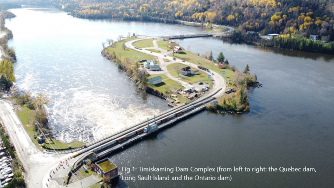
Timiskaming Quebec Dam-Bridge Replacement Project
Want to learn more about the Timiskaming Dam-Bridge Project and the associated Algonquin Knowledge and Land Use Study?
An Information Session was held on Thursday, May 13th, 2021 on Zoom to provide more context on the Algonquin Knowledge and Land Use Study. If you missed this, or want to review the presentations, they are linked below:
Public Services and Procurement Canada (PSPC) Presentation
Shared Value Solutions (SVS) Presentation
If you are interested in providing feedback and information regarding this project through a survey, please complete this survey:
Environmental Assessment Notice
Public Services and Procurement Canada (PSPC) is proposing to replace the Quebec portion of the Timiskaming Dam-Bridge Complex, which is located on the Kichi-Sìbì (Ottawa River). This proposal is currently subject to a federal environmental assessment (EA) process under the Canadian Environmental Assessment Act (CEAA, 2012). An important part of this EA process is to inform Indigenous groups how the proposed dam-bridge replacement may occur and gather feedback on how this may affect inherent Indigenous and/or Treaty rights or suggest project improvements. PSPC’s intent is to conduct this engagement with a collaborative, nation-to-nation perspective reflective of a renewed relationship with Indigenous peoples.
Project Description
The Timiskaming Dam Complex was originally built between 1909 and 1913 and rebuilt in 1934 because of a foundation failure. Located on either side of Long Sault Island on the Ottawa River, the complex comprises two structurally independent dams: the Ontario dam and the Quebec dam. Ontario portion of the Timiskaming Dam Complex was completed in March 2017.
Although it is still safe, it is nearing the end of its useful life and needs to be replaced. The dams control the water level in Lake Timiskaming upstream, the flow of the Ottawa River downstream, the last major reservoir on the Ottawa River upstream of the St. Lawrence River at Montréal and provide water storage for hydroelectric generation downstream. The complex is also an important interprovincial road for motorists, cyclists and pedestrians, and it accommodates a natural gas pipeline.
The purpose of the project is to build a new structure approximately 25 metres downstream of the existing dam, to build a fish passage and to demolish the old structure. Its deck will continue to support a two-lane roadway connecting the provinces of Quebec and Ontario.
For more project specific information, click here.
Announcing Our Next Algonquin Knowledge and Land Use Study!
The Algonquins of Ontario (AOO) are pleased to announce the commencement of our latest Algonquin Knowledge and Land Use Study (AKLUS) focused on the land and waters around the Timiskaming Dam-Bridge of Quebec, which PSPC is proposing to replace. The purpose of an AKLUS is to gather information from Algonquins to help protect important ecological, cultural, and archaeological sites, and reduce potential impacts to our lands and waters from proposed development projects such as infrastructure, forestry, energy and nuclear facilities. This study builds upon the recently completed AKLUS focused on the land and waters around Canadian Nuclear Safety Commission (CNSC) Licensed Facilities within the unceded Algonquin Traditional Territory. This new study is another step towards realizing our goal of collecting and mapping Algonquin Knowledge and land use across all of the unceded Algonquin Traditional Territory.
What does an Algonquin Knowledge and Land Use Study Look Like?
An AKLUS maps community knowledge and land use by conducting one-on-one interviews with Algonquin citizens or those with Algonquin Knowledge. The study team asks participants to share what activities (hunting, fishing, trapping, gathering medicines, conducting ceremonies, for example) and places on the land are important to them, where they hold knowledge of the land, and what stories about their experiences on the land they wish to share. This information is recorded and mapped, creating a “map biography,” or story, of the participant’s relationship with the land. The combined map of all these stories will create a compelling picture of Algonquin connections to our Traditional Territory.
Confidentiality
We know that safeguarding the confidentiality of all participants and protecting sensitive locations of Algonquin Knowledge is of the utmost importance. We have developed an Algonquin Information Governance Protocol to give individuals as well as their Algonquin communities control over how data is collected, shared and stored. Control over information starts with the individual, and each individual participating in the study and their respective Algonquin community will be able to determine the appropriate level of data sharing.
Preserving Cultural Knowledge for Future Generations
For more information about the Timiskaming Dam-Bridge of Quebec Replacement Project and the Algonquin Knowledge and Land Use Study please click here.
Thank you for your interest in this exciting project.
We look forward to hearing from you!
*Special Note: Antoine First Nation and Algonquins of Pikwakanagan First Nation are undertaking their own consultation and engagement process with PSPC for this project (including separate AKLUS). Members of these communities are welcome to participate in the AOO AKLUS, but please reach out to your respective ANRs for more information on these separate processes.
The funding for this project was graciously provided by Public Services and Procurement Canada.

